
Loc:Scel
Loc:Scel
Loc:Scel
Digital support for the criminal investigation department
Digital support for the criminal investigation department
Digital support for the criminal investigation department
This bachelor thesis Loc:Scel is a concept to support investigating officers during the ‘first attack’. Loc:Scel assists with the exchange of information, the recording of evidence, the coordination of tasks and the logging of data. This makes the work of the officers more efficient and measures or background investigations can be initiated more quickly.
This bachelor thesis Loc:Scel is a concept to support investigating officers during the ‘first attack’. Loc:Scel assists with the exchange of information, the recording of evidence, the coordination of tasks and the logging of data. This makes the work of the officers more efficient and measures or background investigations can be initiated more quickly.
This bachelor thesis Loc:Scel is a concept to support investigating officers during the ‘first attack’. Loc:Scel assists with the exchange of information, the recording of evidence, the coordination of tasks and the logging of data. This makes the work of the officers more efficient and measures or background investigations can be initiated more quickly.
Lack of equipment and complicated communication
Lack of equipment and complicated communication
Lack of equipment and complicated communication
A lack of access to up-to-date technologies and a lack of solutions tailored to the criminal investigation department make the work of officers more difficult. In combination with outdated communication structures, this leads to errors in the exchange of information. Due to the many different communication bridges and communication channels such as digital radio and telephone, it is not possible to obtain a standardised picture of the investigation and situation. This is further complicated by analogue logging when working at the scene of an incident and the inability to efficiently coordinate teams at the scene. "Information has to be structured and digitised afterwards at great expense.”
A lack of access to up-to-date technologies and a lack of solutions tailored to the criminal investigation department make the work of officers more difficult. In combination with outdated communication structures, this leads to errors in the exchange of information. Due to the many different communication bridges and communication channels such as digital radio and telephone, it is not possible to obtain a standardised picture of the investigation and situation. This is further complicated by analogue logging when working at the scene of an incident and the inability to efficiently coordinate teams at the scene. "Information has to be structured and digitised afterwards at great expense.”
A lack of access to up-to-date technologies and a lack of solutions tailored to the criminal investigation department make the work of officers more difficult. In combination with outdated communication structures, this leads to errors in the exchange of information. Due to the many different communication bridges and communication channels such as digital radio and telephone, it is not possible to obtain a standardised picture of the investigation and situation. This is further complicated by analogue logging when working at the scene of an incident and the inability to efficiently coordinate teams at the scene. "Information has to be structured and digitised afterwards at great expense.”
How can we create a solution that provides a
comprehensive and seamless overview of the scene
of the incident and the events leading up to it,
thereby serving as a working basis for the further
investigation process?
How can we create a solution that provides a
comprehensive and seamless overview of the scene
of the incident and the events leading up to it,
thereby serving as a working basis for the further
investigation process?
How can we create a solution that provides a
comprehensive and seamless overview of the scene
of the incident and the events leading up to it,
thereby serving as a working basis for the further
investigation process?
Information exchange and logging
Information exchange and logging
Information exchange and logging
In order to improve the comprehensibility of crime scene work, the central players in a criminal case were examined: investigating officers, SoKo, the public prosecutor's office and the command and situation centre. Requirements for functions, accessibility and interfaces were analysed in order to develop an intuitive and efficient system for the exchange of information. The SoKo creates and distributes orders to the coordination team, which in turn forwards them to incoming teams. While the SoKo assesses and processes the investigation and situation, the first arriving unit takes over the coordination on site. Subsequent squads receive their orders via the application, but can suggest follow-up orders. The user-friendly design with minimalist and clear interfaces ensures fast and safe use at the crime scene.
In order to improve the comprehensibility of crime scene work, the central players in a criminal case were examined: investigating officers, SoKo, the public prosecutor's office and the command and situation centre. Requirements for functions, accessibility and interfaces were analysed in order to develop an intuitive and efficient system for the exchange of information. The SoKo creates and distributes orders to the coordination team, which in turn forwards them to incoming teams. While the SoKo assesses and processes the investigation and situation, the first arriving unit takes over the coordination on site. Subsequent squads receive their orders via the application, but can suggest follow-up orders. The user-friendly design with minimalist and clear interfaces ensures fast and safe use at the crime scene.
In order to improve the comprehensibility of crime scene work, the central players in a criminal case were examined: investigating officers, SoKo, the public prosecutor's office and the command and situation centre. Requirements for functions, accessibility and interfaces were analysed in order to develop an intuitive and efficient system for the exchange of information. The SoKo creates and distributes orders to the coordination team, which in turn forwards them to incoming teams. While the SoKo assesses and processes the investigation and situation, the first arriving unit takes over the coordination on site. Subsequent squads receive their orders via the application, but can suggest follow-up orders. The user-friendly design with minimalist and clear interfaces ensures fast and safe use at the crime scene.
Core functions
Core functions
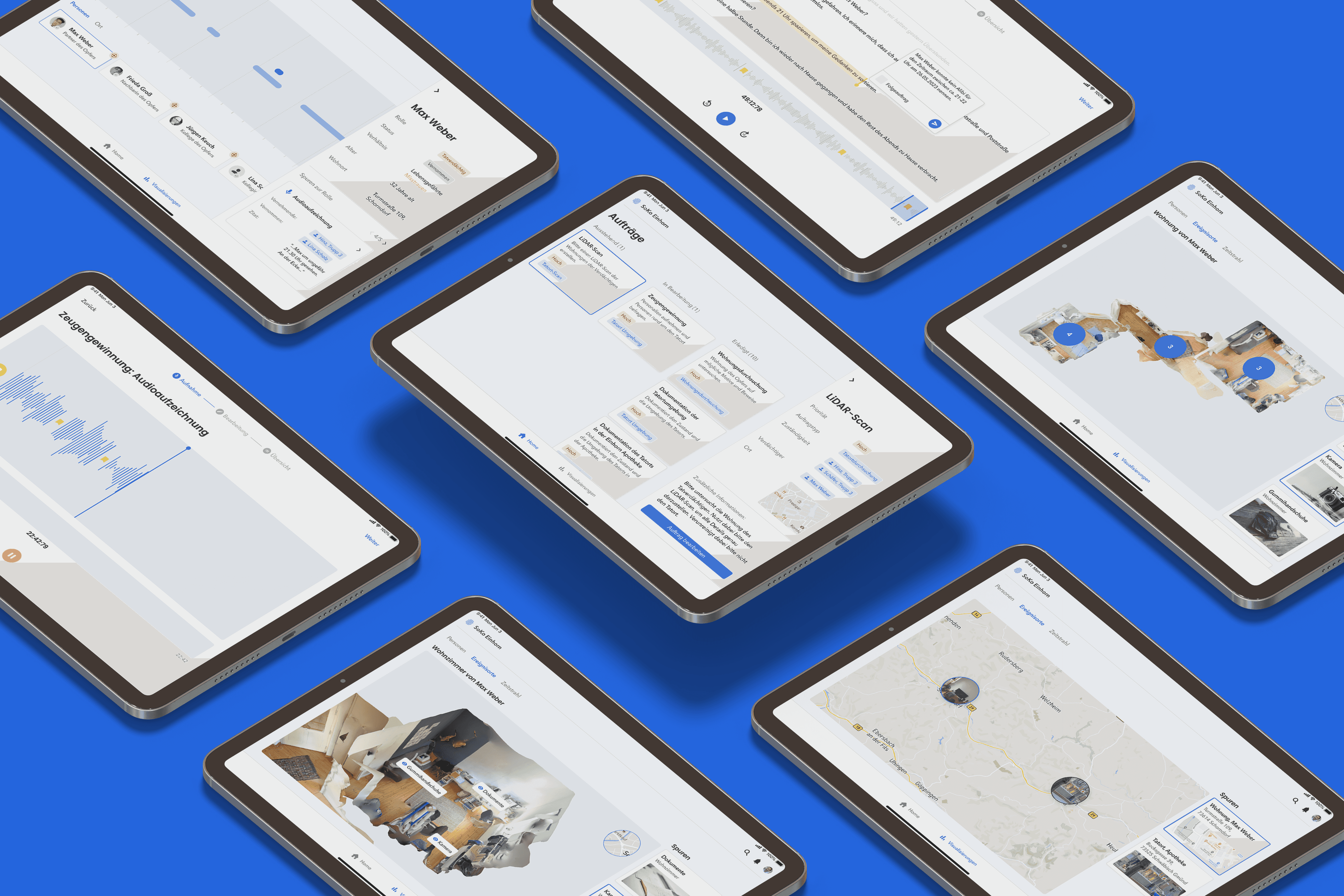
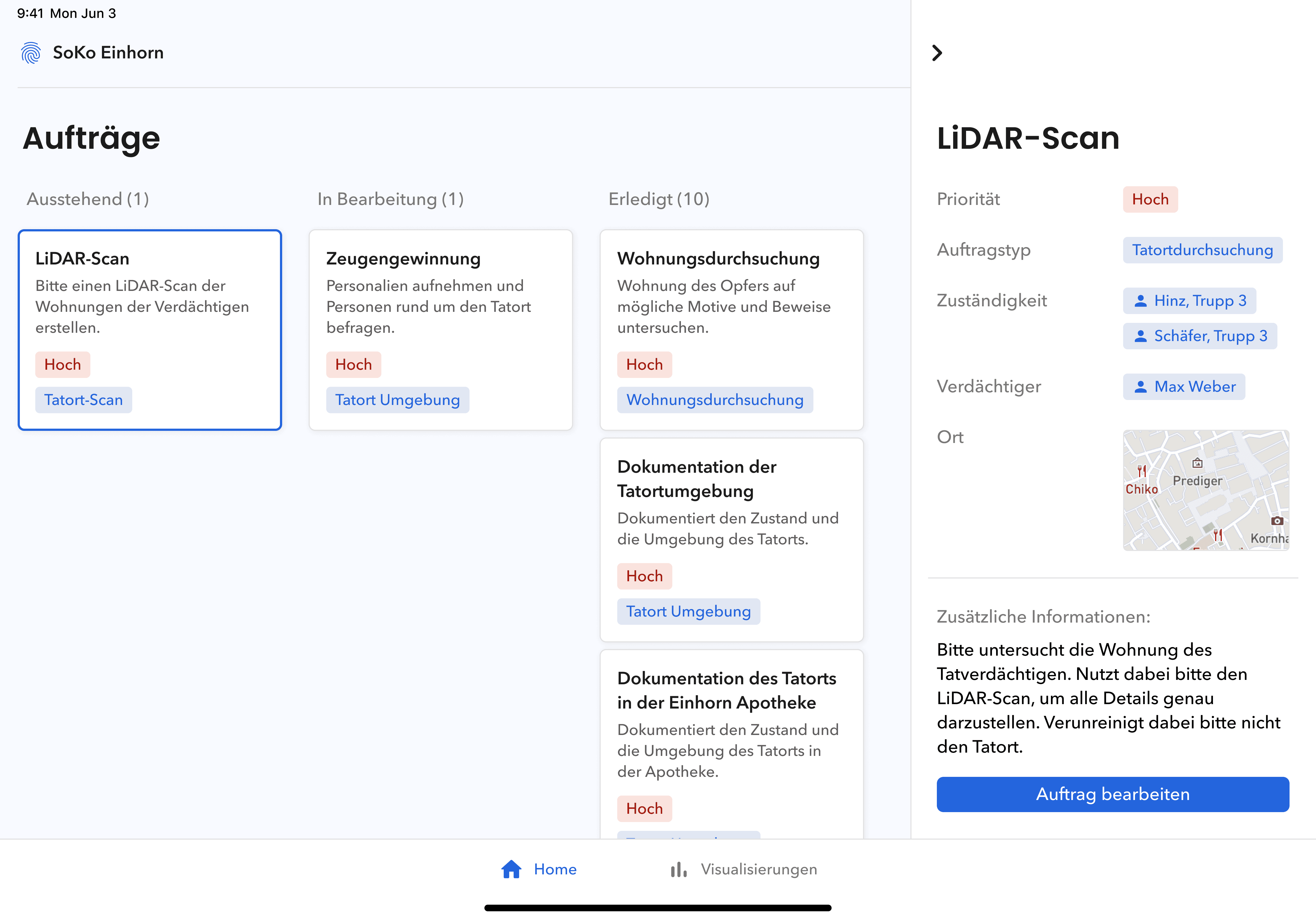
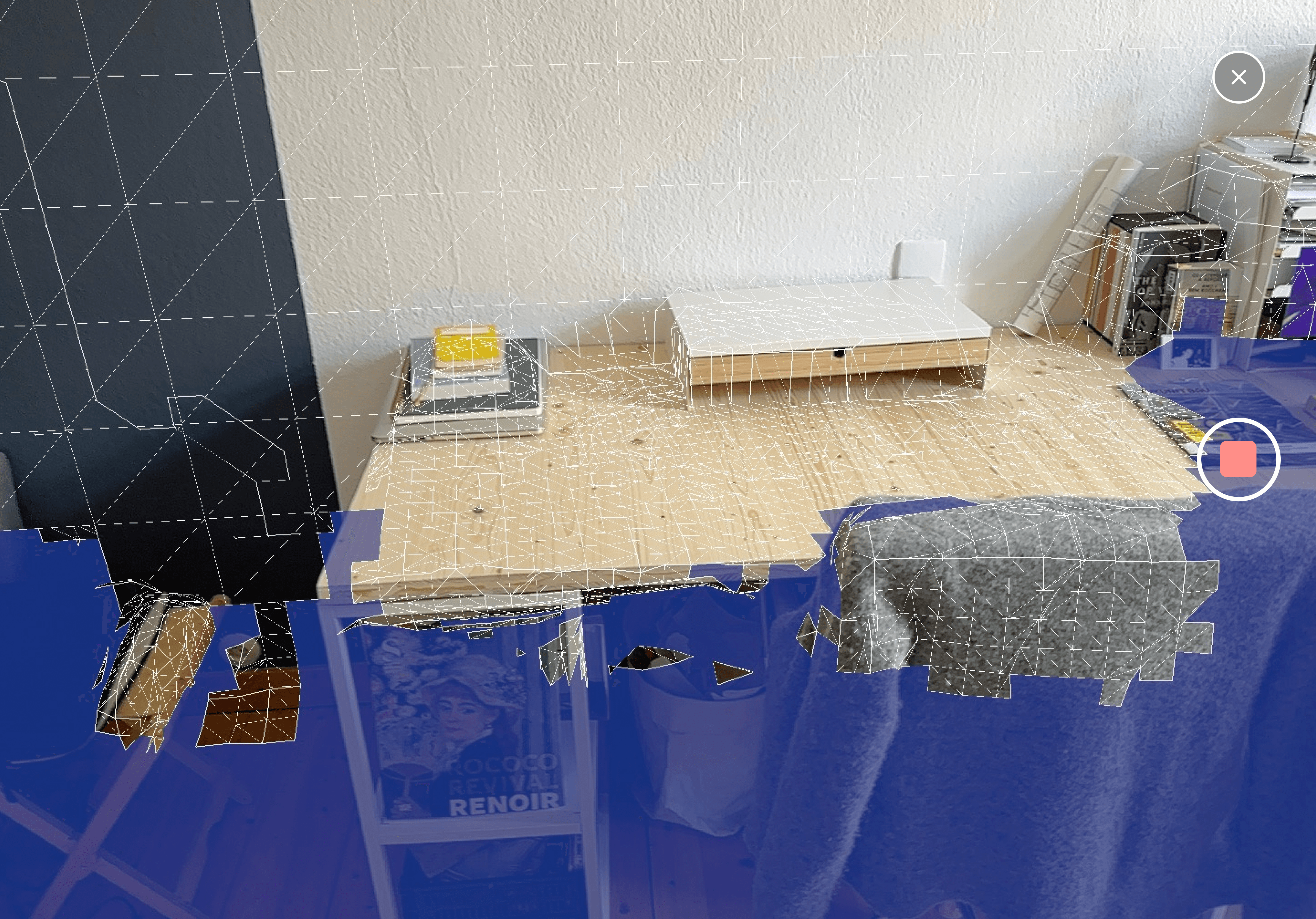
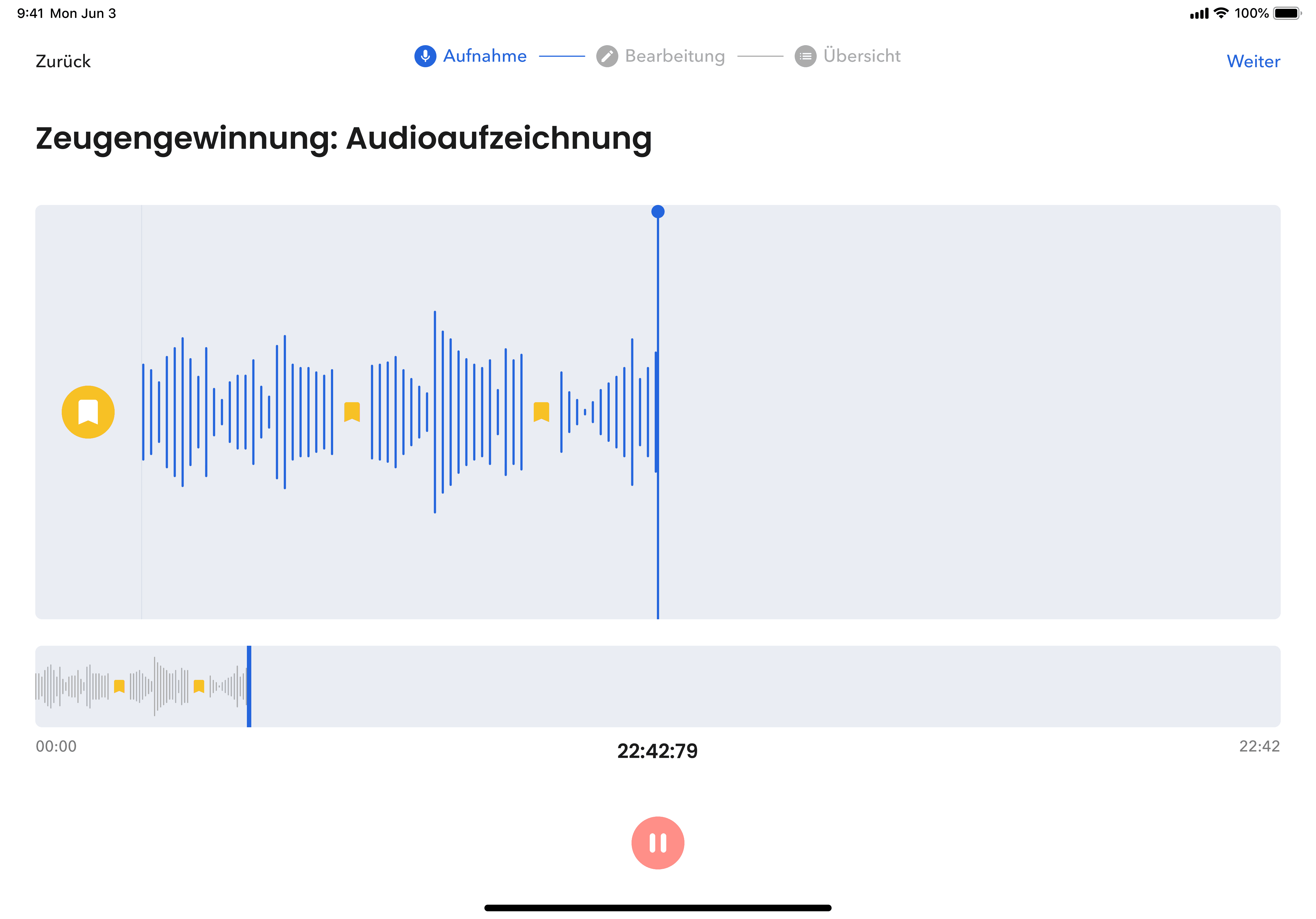
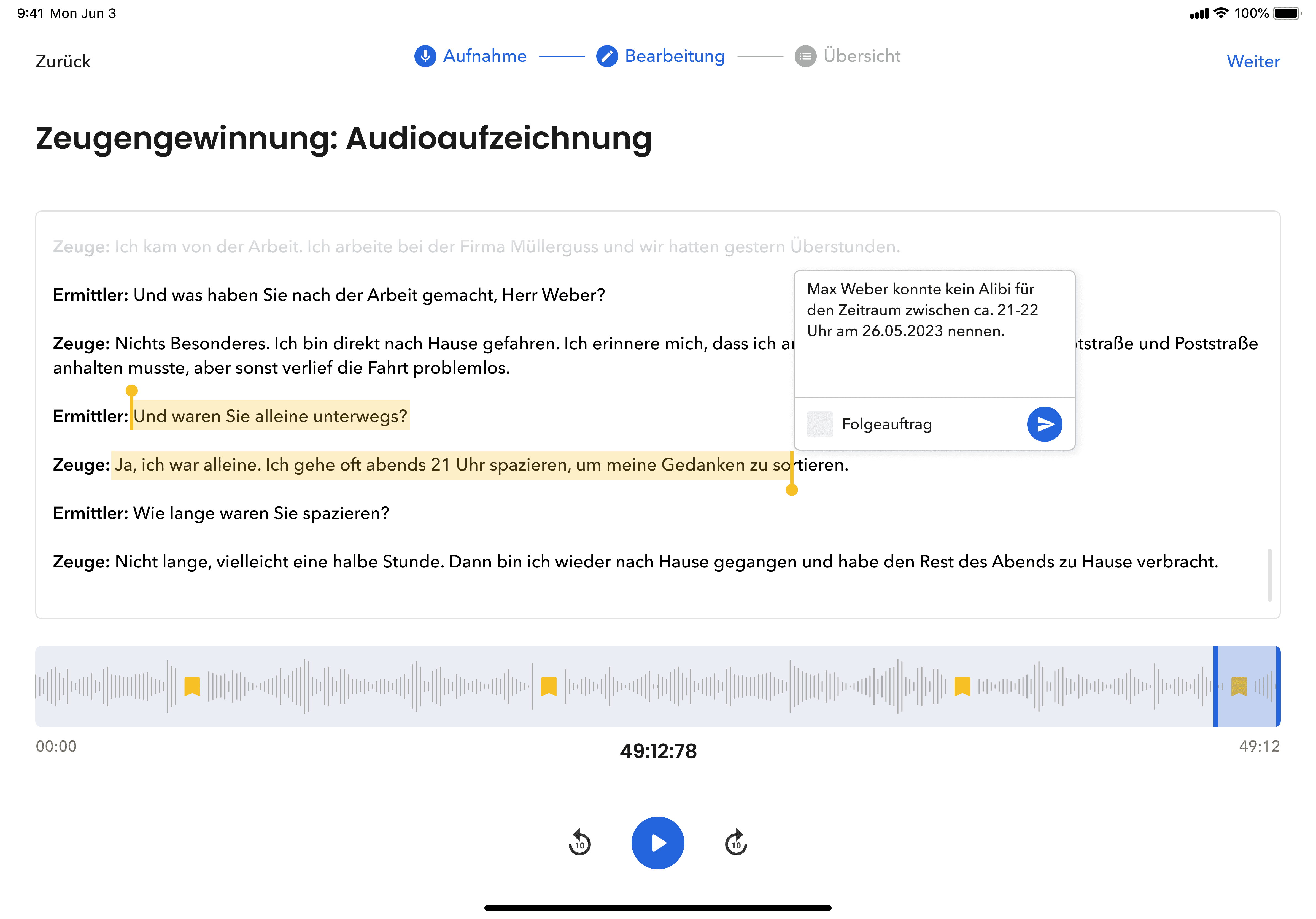
The application offers central functions for the digital logging and visualisation of evidence. Media such as audio recordings, photos and LiDAR scans are provided with tags for ‘location’ and ‘person’, enabling structured categorisation according to location, persons involved and time. Modern technologies such as machine learning and natural language processing support the officers by automatically recognising data points, converting audio recordings into text and analysing photos for relevant information such as names or times. This optimises the investigative work and facilitates data processing.
The application offers central functions for the digital logging and visualisation of evidence. Media such as audio recordings, photos and LiDAR scans are provided with tags for ‘location’ and ‘person’, enabling structured categorisation according to location, persons involved and time. Modern technologies such as machine learning and natural language processing support the officers by automatically recognising data points, converting audio recordings into text and analysing photos for relevant information such as names or times. This optimises the investigative work and facilitates data processing.
The application offers central functions for the digital logging and visualisation of evidence. Media such as audio recordings, photos and LiDAR scans are provided with tags for ‘location’ and ‘person’, enabling structured categorisation according to location, persons involved and time. Modern technologies such as machine learning and natural language processing support the officers by automatically recognising data points, converting audio recordings into text and analysing photos for relevant information such as names or times. This optimises the investigative work and facilitates data processing.

Visualisations
Visualisations
Visualisations
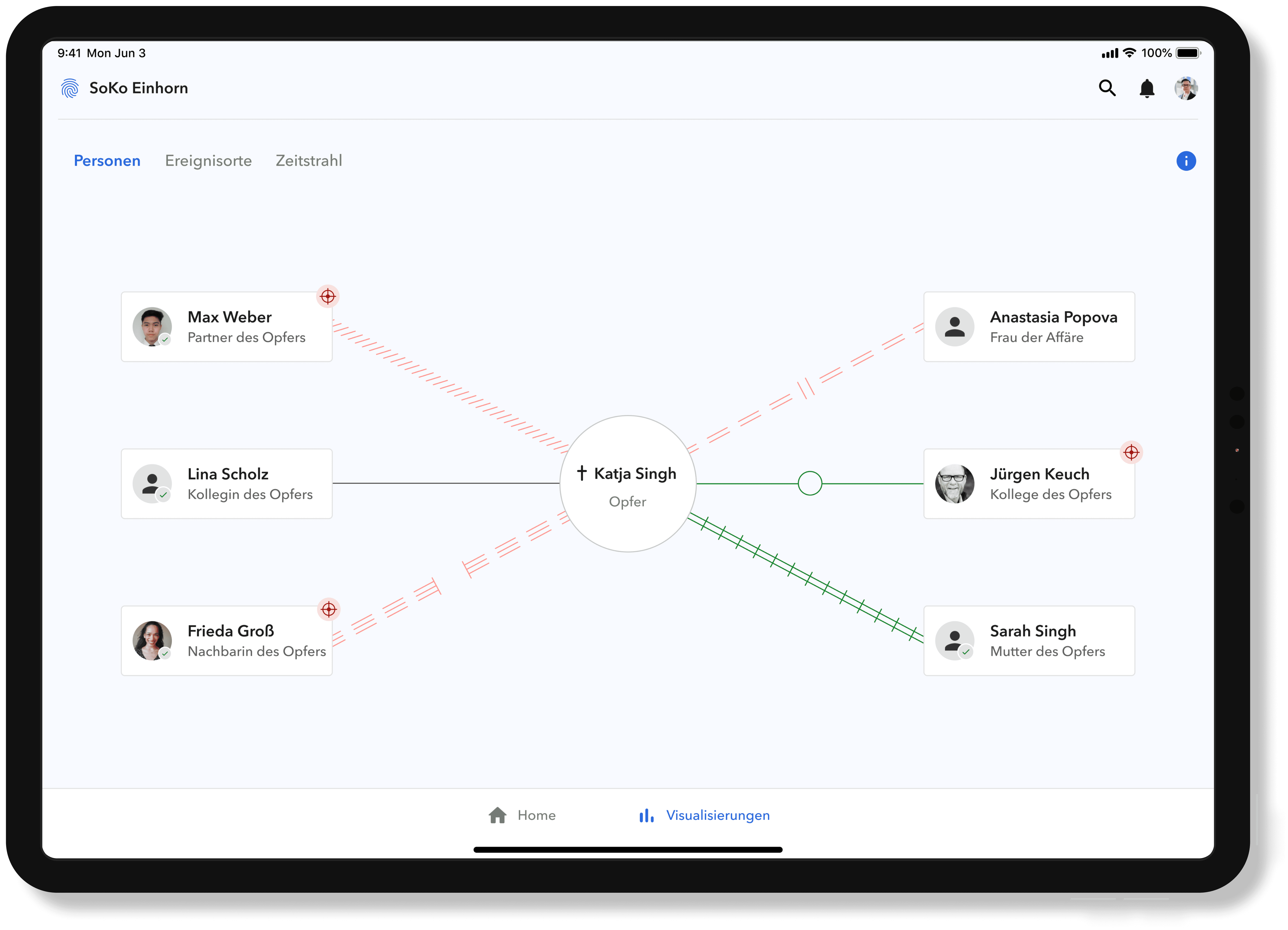
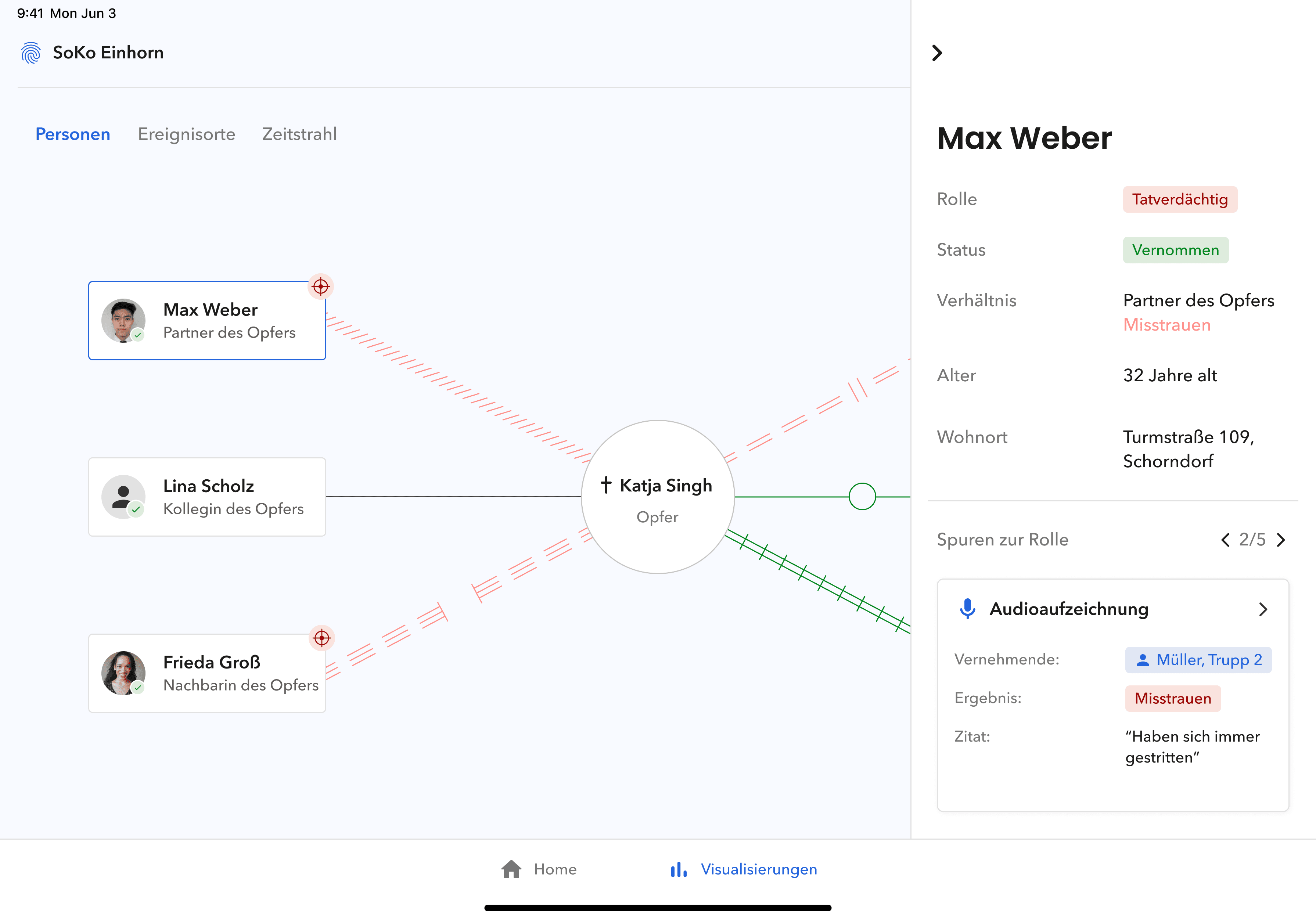
In the ‘persons’ display, the criminal investigation officers have the option of viewing all persons already identified and their relationship to the victim. Based on this, the victim is arranged in the centre of the display. Based on the use of genograms from family research, various line structures are used to depict close emotional connections, conflicts and abuse. They serve as a connecting element between the victim and the identified persons.
In the ‘persons’ display, the criminal investigation officers have the option of viewing all persons already identified and their relationship to the victim. Based on this, the victim is arranged in the centre of the display. Based on the use of genograms from family research, various line structures are used to depict close emotional connections, conflicts and abuse. They serve as a connecting element between the victim and the identified persons.
In the ‘persons’ display, the criminal investigation officers have the option of viewing all persons already identified and their relationship to the victim. Based on this, the victim is arranged in the centre of the display. Based on the use of genograms from family research, various line structures are used to depict close emotional connections, conflicts and abuse. They serve as a connecting element between the victim and the identified persons.
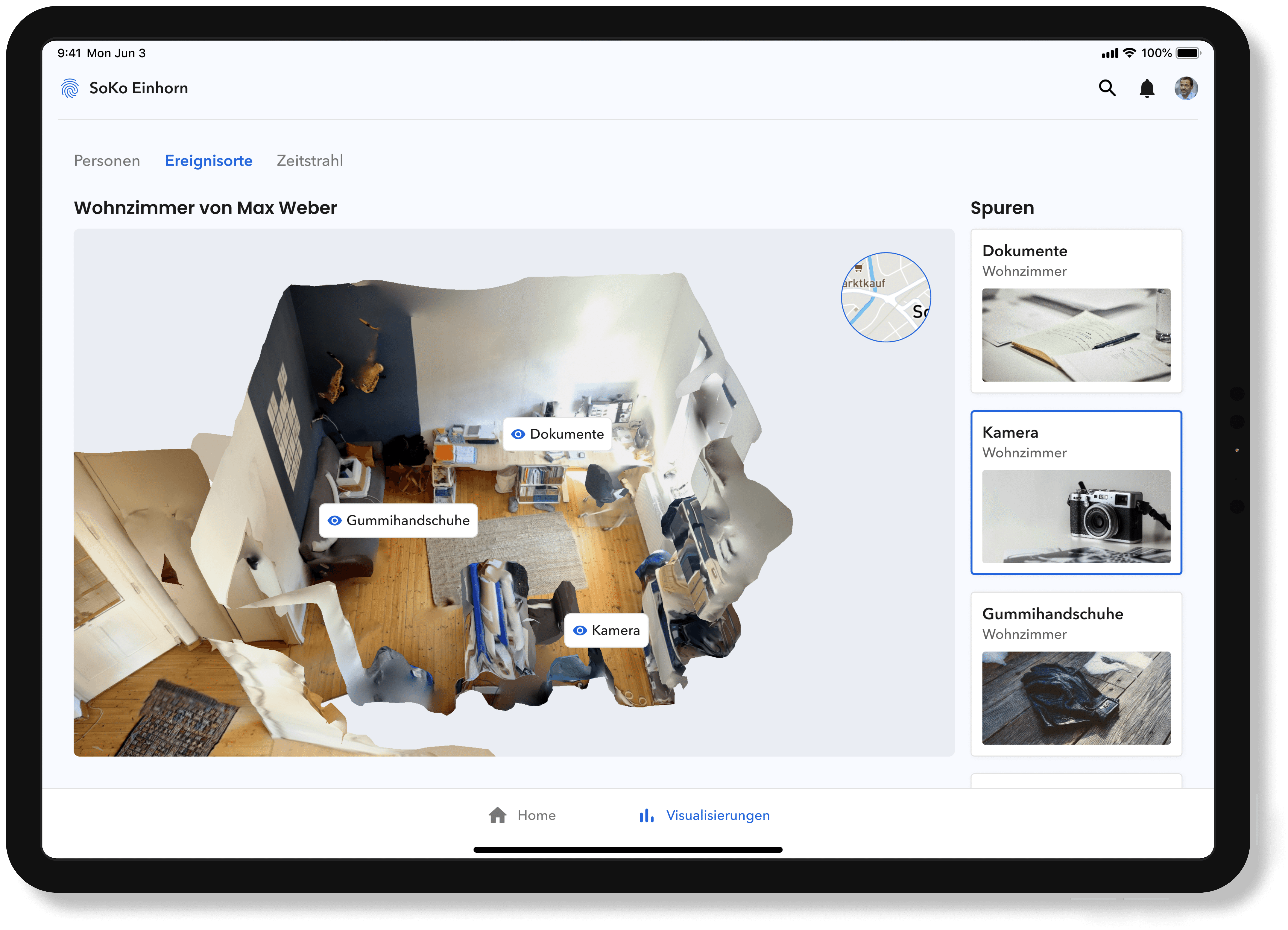
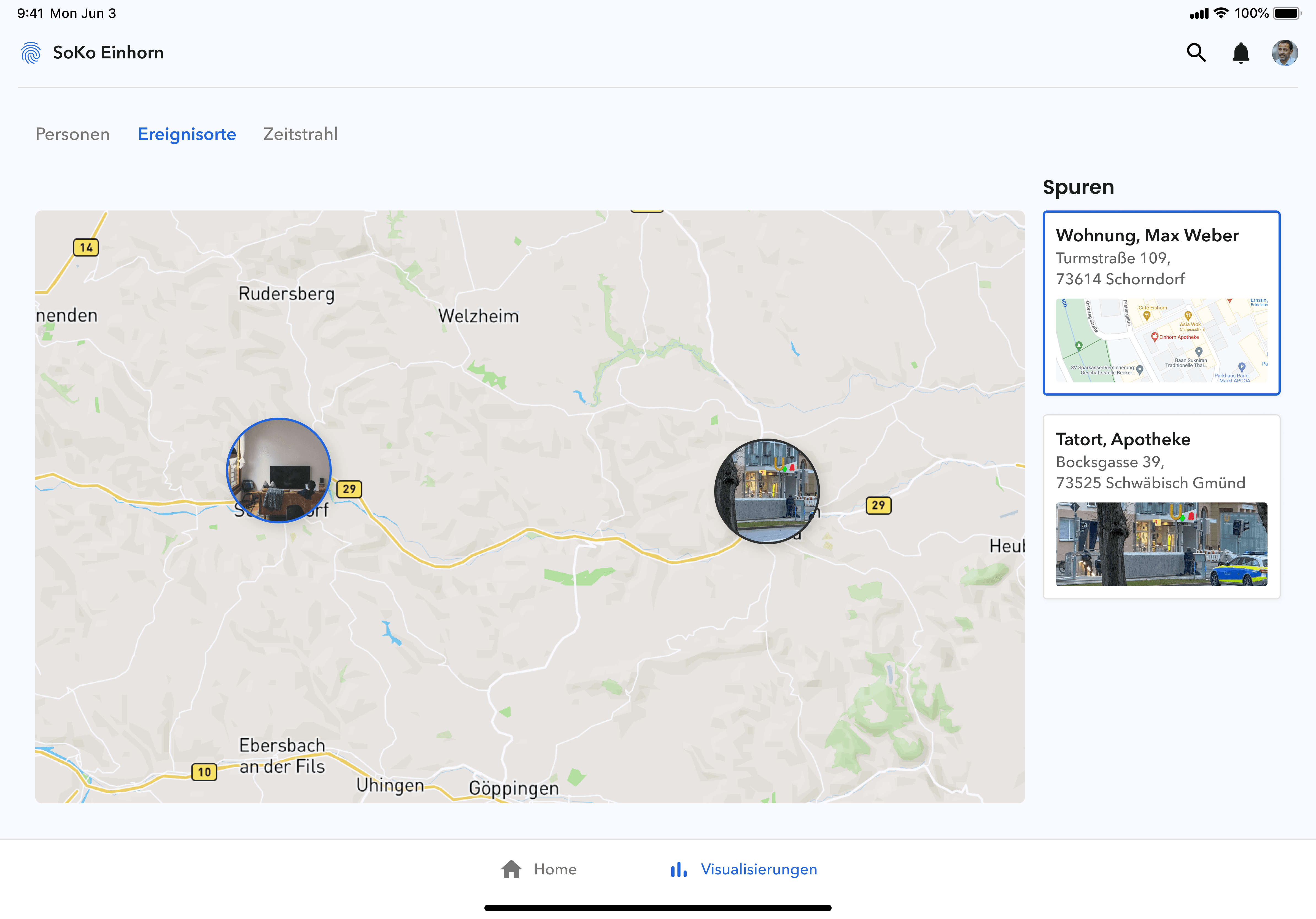
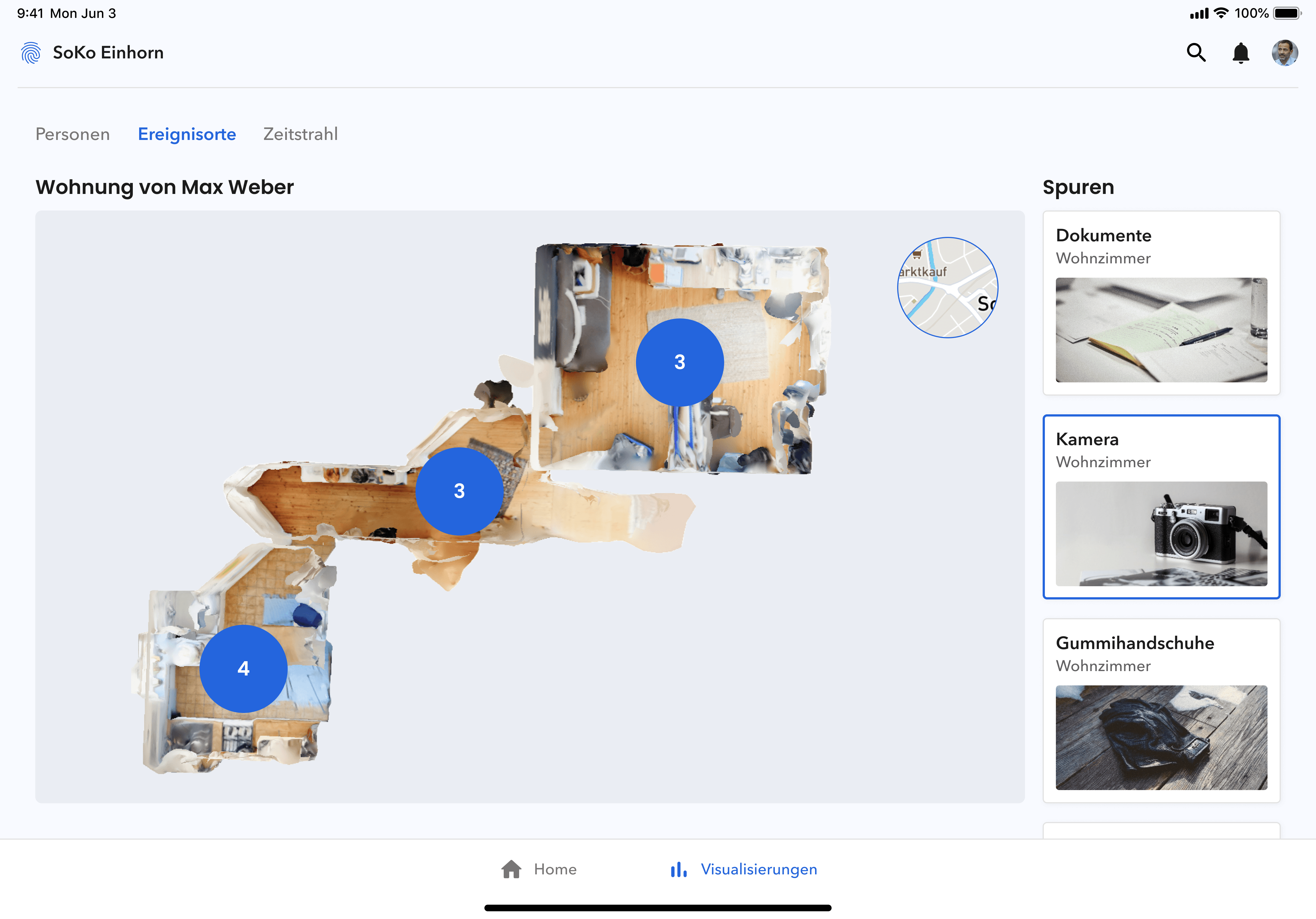
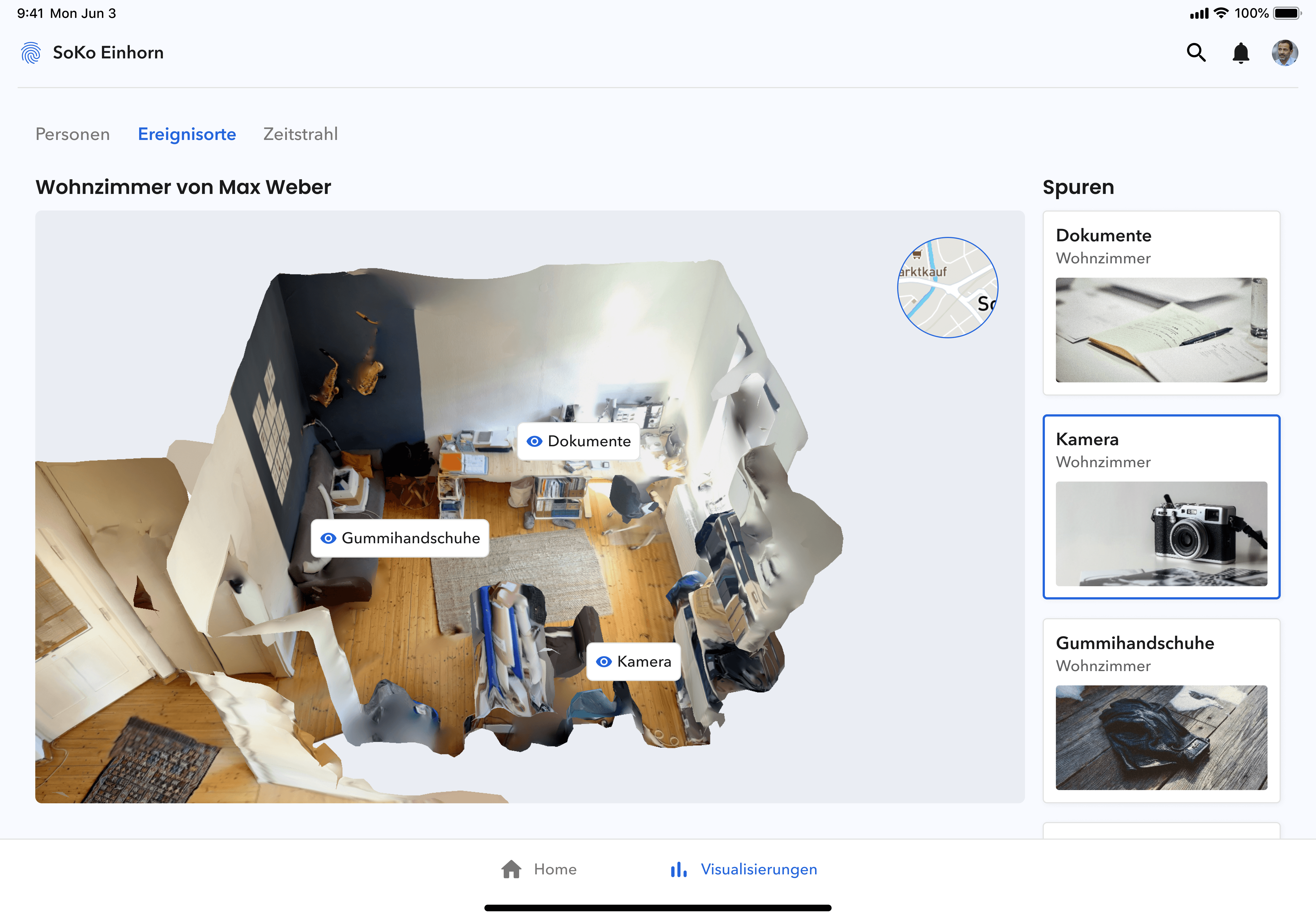
The ‘event locations’ view is used to contextualise the collected traces and event locations within a local framework. The starting point of the display is a map in which the event location(s) and the persons assigned to them are positioned in a local context. By clicking on a location, the view switches to the recorded LiDAR scans. The collected tracks can be viewed in the local context both in the complete view of the scan and when switching to the individual rooms or areas. By clicking on a track, the detailed information recorded by officers is displayed in a side peek.
The ‘event locations’ view is used to contextualise the collected traces and event locations within a local framework. The starting point of the display is a map in which the event location(s) and the persons assigned to them are positioned in a local context. By clicking on a location, the view switches to the recorded LiDAR scans. The collected tracks can be viewed in the local context both in the complete view of the scan and when switching to the individual rooms or areas. By clicking on a track, the detailed information recorded by officers is displayed in a side peek.
The ‘event locations’ view is used to contextualise the collected traces and event locations within a local framework. The starting point of the display is a map in which the event location(s) and the persons assigned to them are positioned in a local context. By clicking on a location, the view switches to the recorded LiDAR scans. The collected tracks can be viewed in the local context both in the complete view of the scan and when switching to the individual rooms or areas. By clicking on a track, the detailed information recorded by officers is displayed in a side peek.
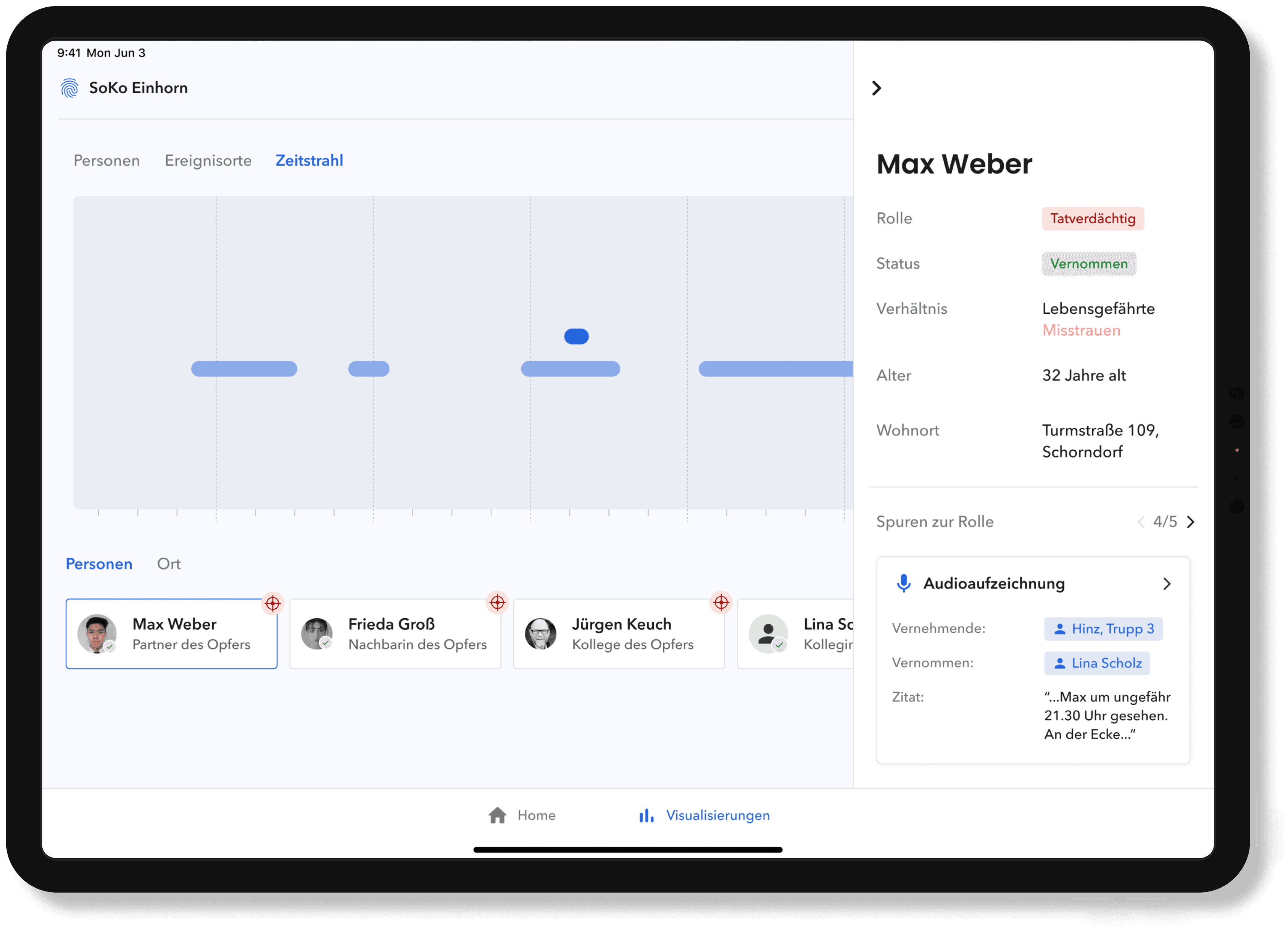
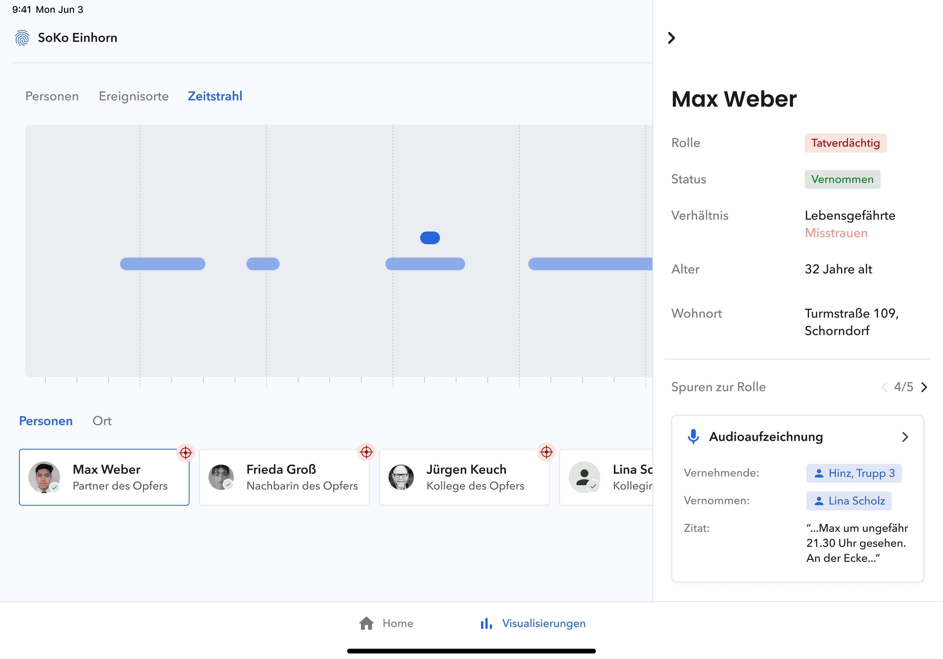
In the ‘timeline’ display, the tracks are localised with their metadata in a temporal context. The temporal localisation of the tracks in relation to a person or a place is considered here. The view is divided into two areas, the interaction area and the visualisation area. In the interaction area, you can switch between the categories ‘places’ and ‘people’. The display takes place in the visualisation area. Depending on the category, the recorded traces of the selected places or persons are visualised in a chronological sequence.
In the ‘timeline’ display, the tracks are localised with their metadata in a temporal context. The temporal localisation of the tracks in relation to a person or a place is considered here. The view is divided into two areas, the interaction area and the visualisation area. In the interaction area, you can switch between the categories ‘places’ and ‘people’. The display takes place in the visualisation area. Depending on the category, the recorded traces of the selected places or persons are visualised in a chronological sequence.
In the ‘timeline’ display, the tracks are localised with their metadata in a temporal context. The temporal localisation of the tracks in relation to a person or a place is considered here. The view is divided into two areas, the interaction area and the visualisation area. In the interaction area, you can switch between the categories ‘places’ and ‘people’. The display takes place in the visualisation area. Depending on the category, the recorded traces of the selected places or persons are visualised in a chronological sequence.
Project information
Project information
Project information
Year: 2023
Year: 2023
Year: 2023
Duration: six months
Duration: six months
Duration: six months
Client: HfG Schwäbisch Gmünd
Client: HfG Schwäbisch Gmünd
Client: HfG Schwäbisch Gmünd
Course: bachelor’s thesis
Course: bachelor’s thesis
Course: bachelor’s thesis
Partner: Alisa Bogukanin, Malte Opderbeck, Marie Köhle
Partner: Alisa Bogukanin, Malte Opderbeck, Marie Köhle
Partner: Alisa Bogukanin, Malte Opderbeck, Marie Köhle


© Adrian Jans 2025 | Imprint | Privacy Policy
© Adrian Jans 2025 | Imprint | Privacy Policy
© Adrian Jans 2025